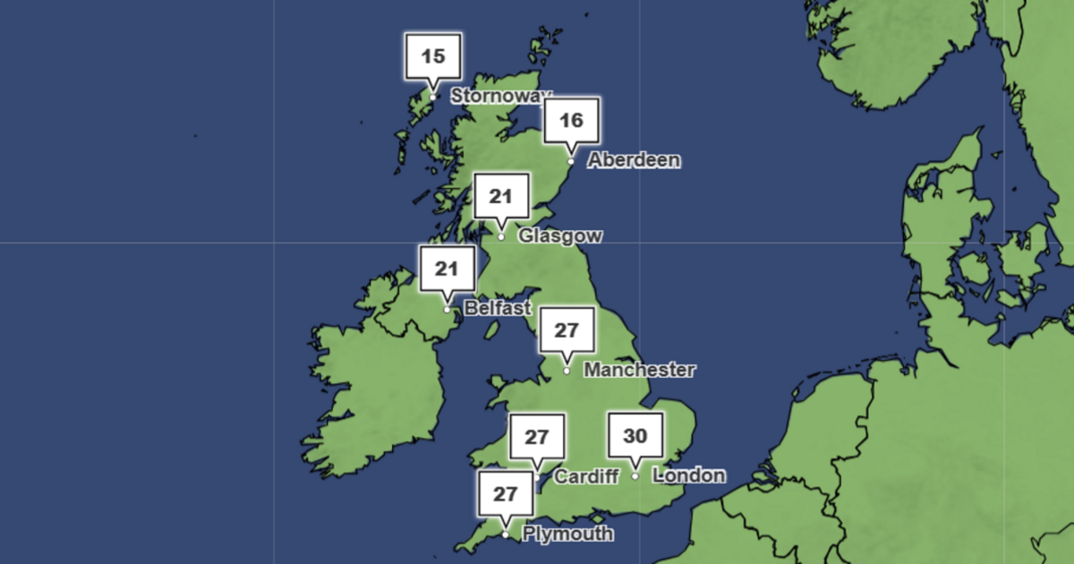

The UK is predicted to see another summer heat blast, with the latest Met Office weather maps showing temperatures climbing into the high 20s, even early 30s across parts of England and Wales next week. The latest forecast charts, generated on June 17, indicate that Southampton, London and its surrounding counties could reach a sweltering 30C by 4pm next Monday (June 22), while much of the rest of the UK's southern nations will enjoy temperatures above 27C.
Met Office temperature maps for 4pm on June 22 the hottest conditions concentrated across central and southwestern England and south Wales, while eastern England, Scotland and Northern Ireland remain noticeably cooler. By 7pm, temperatures remain remarkably high, with London still forecast to be at 30C, while areas like Brighton and Exeter remain at 27C. Further north, temperatures in Northern Ireland are predicted to peak at 21C by 4pm on Monday, while conditions in Scotland hang around the mid-to-high teens.
A more detailed map of England and Wales shows that a total of 10 areas, including major cities such as Southampton, Cardiff, Exeter, Plymouth, Brighton and Birmingham, are all set to enjoy temperatures above 27C by 4pm on Monday, with these highs hanging around into the evening.
By 10pm, temperatures are set to drop, with the peak of 26C still predicted fo London and low 20s across the rest of England.
While not all Brits will see the heat surge, the vast majority will enjoy clear skies on Monday, with the Met Office's latest rainfall maps predicting no precipitation for all of Wales and southern England, with only a small patch of rain expected for the northeastern coast of England and around York at 4am. Parts of Northern Ireland and Scotland will see rain, as a large band sweeps in from the Atlantic throughout the day.
The Met Office's long-range forecast for the period June 21 to June 30 reads: "Probably a north-south split at the start of this period. In the north, changeable and often rather cloudy with showers or some longer spells of rain, perhaps heavy at times, and temperatures near normal.
"In the south, mainly fine and dry with temperatures well above normal, albeit with a small risk of a few showers or thunderstorms at times. Into late June, high pressure may begin to build with conditions becoming more widely dry and settled. Temperatures are likely to be above normal for many areas."
Regarding its long-range forecasting, the Met Office warns: "When looking at forecasts beyond five days into the future, the chaotic nature of the atmosphere begins to play a larger part - small events currently over the Atlantic can have potentially significant impacts on our weather in the UK and Ireland in several days' time".