


Residents in two states have now been urged to prepare, with the Bureau of Meteorology warning Tropical Cyclone Alfred could make landfall anywhere between Bundaberg and northern New South Wales.
The Queensland premier, David Crisafulli, said residents of southeast Queensland should be preparing “canned food and bottled water” as forecasters expect Alfred to shift towards large population centres in the coming days.
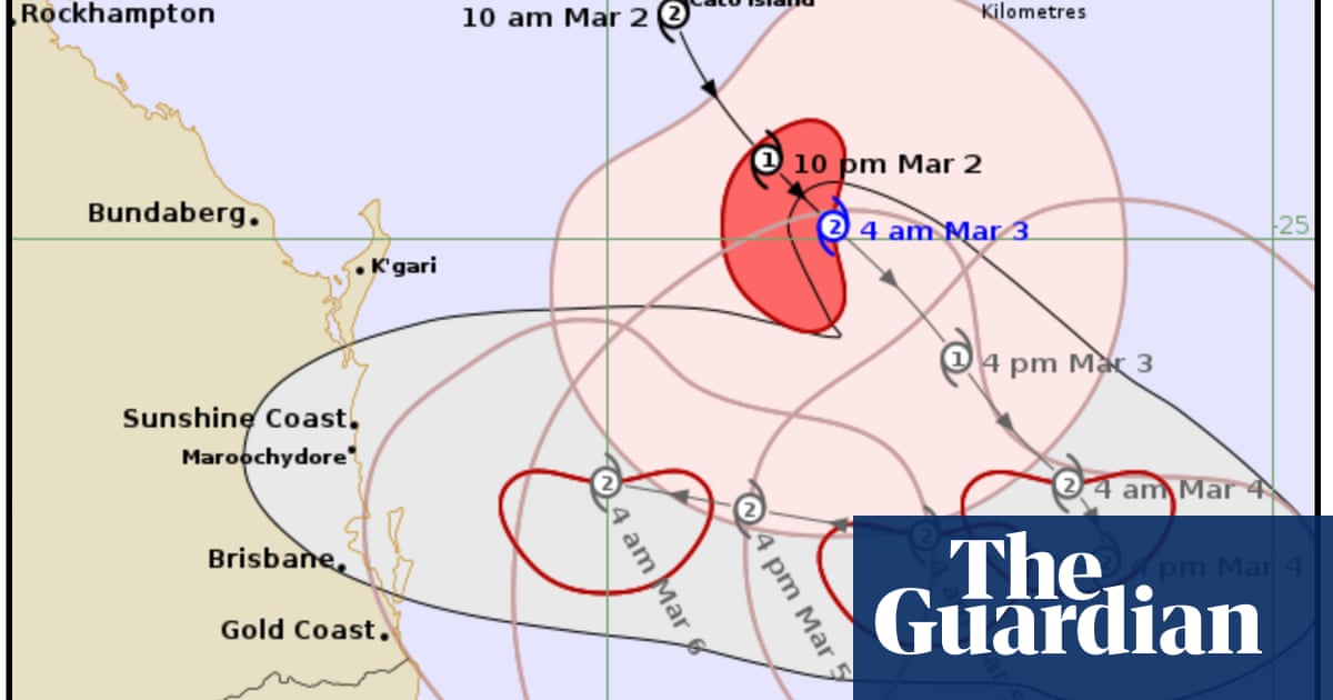
The cyclone is forecast to cross the coastline as a category 2 system on Thursday or early Friday.
Authorities have moved to a preparatory footing several days ahead of the predicted impacts, given the potential path of the cyclone includes the heavily populated areas around Brisbane. The Queensland capital is particularly flood-prone and has been severely inundated three times in the past 15 years.
It is unusual – though not unprecedented – for a Tropical Cyclone to threaten landfall so far south of the tropics.
Speaking on ABC News Breakfast on Monday, Crisafulli urged residents in the south-east – unaccustomed to the sorts of cyclone preparations that are routine in the state’s north – to prepare their homes.
“[People need to] make sure they do things around their own home and make sure they’ve got canned food and bottled water and remove loose items,” Crisafulli said.
“If you do all those things, you do get through these events.”
The Bureau of Meteorology has warned that heavy rainfall will be concentrated to the south of wherever Alfred makes landfall, and that the system could bring 300mm to 600mm over multiple days.
“It’s the rainfall that is most of concern,” Crisafulli said.
“When a system like that does cross the coast, generally speaking you have huge intensities to the south of the system, and that can produce really intense rainfall in a very, very short window
“You’re already dealing with areas that are reasonably soaked already, so there are complications that come with that.”
The more immediate threat, as Alfred moves slowly to the south-east and lingers off the coast, is concern about intense winds and potential storm surge in island communities and along the coast.
Waves up to 14 metres were recorded off Wide Bay on Sunday.
The Brisbane lord mayor, Adrian Schrinner, said many of the city’s residents had never experienced a cyclone before as he stressed the “very real threat” to south-eastern Queensland.
It is rare – but not unheard of – for tropical cyclones to reach landfall south of the tropics.
The closest a cyclone track has come to Brisbane was in 1990, when Tropical Cyclone Nancy tracked erratically towards the Queensland capital, before making a southward turn just off the coastline and never reaching landfall.
Tropical Cyclone Wanda – the cause of Brisbane’s historic 1974 floods – crossed the coast near K’gari and Hervey Bay. A severe tropical cyclone crossed the coast near Tweed Heads in 1954.
It is far more common for a tropical cyclone to cross the coast north of the tropic of capricorn and return overland to the south-east as a destructive low storm. This occurred with Cyclone Debbie in 2017.
In NSW, where the northern coastline could be affected, the State Emergency Service urged residents to prepare for damaging winds, large surf and heavy rainfall with major riverine and flash flooding expected from Wednesday.
“We are asking the community to take steps now to ensure that if you are asked to evacuate you have a plan for yourselves, your families and your pets and know where you will go,” NSW SES assistant commissioner Dean Storey said.
The bureau is predicting that Alfred will move slowly to the south-east until Tuesday, before shifting west back towards the coast.