


New weather maps of the UK are forecasting a rare weather event for next Thursday, February 20.
Freezing rain is predicted to batter northern Wales and possibly creep over parts of Cheshire in the northwest of England, according to weather forecaster, WXCharts.
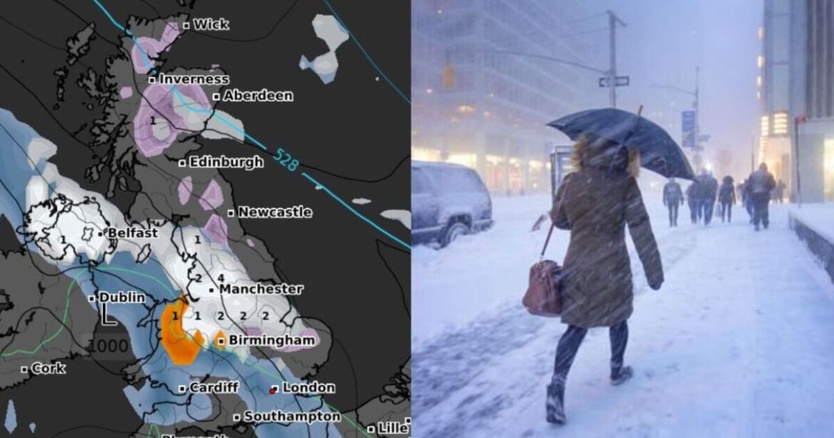
The rare weather phenomenon will fall at a rate of 1mm per hour, shown in bright orange on the map, while areas nearby will be covered in snow.
The Midlands and Northern Ireland are in thick of the snow, with a band of white directly positioned across the centre of the UK.
Manchester seems to be at the centre of the snowstorm with a rate of 4mm set to fall per hour, and with temperatures predicted at 0.25 degrees, it may have chance to settle.
The storm is expected to sweep in at midnight, suggesting icy conditions could still be present in the morning, potentially causing ice on the roads.
From the east to the west coast in line with Nottingham, 2mm of snow will fall per hour overnight, while further north in Liverpool is predicted to receive the same.
Further south will instead be hammered with overnight rain, which will stretch from London to Southampton and Cardiff according to WXCharts.
Dublin in Ireland may also be caught in the storm, however the bulk over the rain seems to skim just over the city before laying the majority over the Irish Sea.
In Scotland, the forecast predicts 1cm of snow will settle over the centre of the country, just missing Aberdeen, Edinburgh and Inverness.
The Met Office predicts “below average temperatures” in its long range forecast between February 15 to 24.
It said: “Meanwhile, Atlantic frontal zones, bringing milder conditions and rain, will attempt to move in from the west or southwest.”
It predicts towards the end of the time period, “milder, wetter conditions are likely to have spread across much of the country”.